
“It’s nuts.”
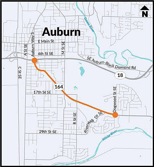
That’s how one Noble Court resident described the trek down State Route 164 from Muckleshoot Hill to Highway 18 and back.
A long trek, one made longer by casino traffic, the woman said, and made positively ghastly, especially on summer evenings, by White River Amphitheatre traffic, one way each way.
“It’s terrible to be honest,” said Lindy, who declined to give her last name. “I’m thinking of selling my house and leaving, going somewhere else.”
Lindy was among dozens who showed up at Chinook Elementary school last Thursday, Feb. 7, to hear what the Washington State Department of Transportation, the Muckleshoot Tribe and the city of Auburn have in mind for the State Route 164 East Auburn Access Improvement Project, which proposes to develop an affordable, long-term solution to the corridor’s well-known problems.
The tribe is the lead on the project, but the funding comes from WSDOT. The city’s role is more technical and advisory.
SR 164 provides primary access to the growing areas of east Auburn, the Muckleshoot Indian Reservation, the city of Enumclaw and recreational areas to the southeast.
Three main goals of the SR 164 project are to:
• Cut congestion, thereby reducing travel times, decreasing lines that block driveways and intersections, and improving reliability for emergency response for the section between SR 18 in Auburn and Dogwood Street Southeast, a segment with recurring congestion and traffic backups that extend through intersections;
• Improve safety by reducing congestion and cutting the potential for collisions. The project will look at options to improve safety for cars, trucks, buses, bikes and people of all abilities; and
• Accommodate growth by allowing for current and future land use in the urban-growth areas of King County, Auburn, Enumclaw and on the Reservation.
Here are the four initial concepts.
Concept 1: Improve the present corridor
Make improvements to the Auburn Way South (SR 164) corridor by adding turn lanes and channelization at congested places, and create potential, grade-separated lanes at the SR 18 interchange.
The benefits of this approach, Acutanza said, are that it uses the current roadway within the right-of-way and presents a low impact to the environment.
On the negative side, she said, the right-of-way and access may hurt existing businesses, and this concept offers limited benefits for reducing congestion, specifically during events.
Concept 2: New local connection
Extend R Street south of Auburn-Black Diamond Road under SR 18 to 17th Street Southeast, and perhaps extend R Street to M Street using 6th Street Southeast and 12th Street Southeast.
The benefits of this concept, Acutanza said, are that it provides a new, north-south regional connection and access to developable land within Auburn’s urban growth area, uses the existing R Street undercrossing and jibes with city plans.
On the downside, this approach may increase traffic across the Burlington-Northern-Santa Fe tracks, constrain right-of-way at the north intersection and does not directly connect to Auburn Way South.
Concept 3: Enhancing access to SR 18
This approach connects Auburn Way South and SR 18 with either new ramps to SR 18 or connects to existing ramps at Auburn-Black Diamond Road. It provides a new roadway connection between SR 18 or Auburn Black Diamond Road and Auburn Way South, somewhere between Muckleshoot Plaza and Dogwood Street Southeast. It provides a new connection between Auburn-Black Diamond Road and M Street Southeast.
Among its benefits, it provides direct, arterial access to SR 18 that bypasses Auburn Way South, could use the existing SR18 ramps at Auburn-Black Diamond Road, and could improve or eliminate the at-grade, skewed, BNSF crossing or allow for a bypass of the crossing via M Street.
But this concept presents challenges, too, among them the construction of costly SR 18 on-ramps that may impact traffic on SR 18, a new roadway connection at Dogwood that would require mitigation of neighboring impacts, and the impact to casino buildings and circulation that could result from the connection at Riverwalk.
Concept 4: Eastern connections to Auburn-Black Diamond Road to Auburn Way S0uth
This alternative connects SR 18 at the Auburn-Black Diamond Road interchange to Auburn Way South, with potential connections at Academy Drive Southeast or Noble Court Southeast, and it uses the existing right-of-way on Green Valley Road. Among the benefits, it provides a new north-south connection and access east of Auburn and a direct, regional connection between SR 18 and Auburn Way South.
The downside of 4 is that it is outside Auburn’s urban growth area, is not identified in the city’s comprehensive plan, traverses steep, unstable slopes, could increase traffic next to schools and impacts heritage sites and farm land, Acutanza said.
The state legislature has provided $15 million for this initial stage of the project, but that amount may be the proverbial drop in the bucket. Indeed, some estimate the cost to the state could approach or exceed $100 million, but the price tag will remain an unknown until the state knows what it’s going to build.
Plus, it will not be the only pricey transportation corridor fix in the state when the time comes to fully fund it.
“How much is it going to cost, I think that’s one of the main factors in all of this, and really, what is the best way to get a better traffic flow in this area?” said Auburn Mayor Nancy Backus. “There’s a bottleneck, we all know it, but some of these options just create a different bottleneck. I’m looking for what is going to be best, not just for an off-ramp but also up the hill that will really mitigate the traffic issues.”
Whatever the solution, it may not be entirely one or another of the four initial concepts sketched out above.
“The preferred alternative could be pieces of multiple concepts, that are combined differently to address congestion, and growth and safety,” said Ingrid Gaub, Auburn city engineer.
In 2008, the state Legislature directed the WSDOT to develop a list of improvement options that addressed the transportation problems on SR 164. It developed the list with a group of representatives from along the highway. At that time, the list of potential improvements included a bypass between SR 164 and SR 18 to address congestion issues at the interchange. In 2006, the Legislature provided $500,000 to further analyze the option.
For more information on the project, check out SR164CorridorImprove@wsdot.wa.gov.
