People who live in River Mobile Estates know that the Reddington levee on the Green River north of Brannan Park in northeast Auburn isn’t up to snuff.
And lest they forget, the water that sloshes through the park when the river rises will be there to refresh their memories.
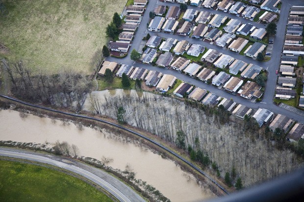
King County officials say that the levee east of the mobile park, built more than 50 years ago to provide flood protection to surrounding agricultural lands, and prone to seepage, is not up to today’s design and construction standards.
“The Reddington levee contains the 100-year-flood event in that channel as it is right now, but that’s about all it does,” said Steve Bleifuhs, manager of the River and Floodplain Management Section of King County. “In terms of its construction, we know it’s not adequate.”
The problem is that its makers put the levee on the river side of a former channel, which is a wetland today. So while the levee keeps the flood within the channel, it cuts off the wetland that stores the water at the same time, backing it up and flooding the adjacent mobile home park.
Devastating flooding impacts are possible if a flood exceeds the channel capacity through that section of the river.
But this is the year that the King County Flood Control District, a special taxing district created by King County residents, rolls up its sleeves and gets busy on the levee’s replacement.
The project removes the existing levee, while building its replacement further west from the river. It also extends it 6,600 feet north from 26th Street at the southern boundary of Brannan Park to the northern boundary of Monterey Park.
The second phase, in the early discussion stage only — would extend the levee beyond the northern end of Phase 1 to S. 277th Street.
There is no money for Phase 2 — not yet. But City officials hope that by the time the first phase is finished, the KCFCD will have the money and be ready to roll on Phase 2. But even if this final phase is not built for years, City Public Works Director Dennis Dowdy recently told members of the Planning and Community Development Committee, the new levee will stand on its own as a significant improvement for the residents of River Mobile Home Estates.
“It does provide for the mobile home park a tremendous benefit that we don’t have right now, which is they have a very seeping levee in front of them now,” said Dowdy. “The moment we get phase 1 built, all the residents of this mobile home park will be much better protected than they are today.”
While the project will widen the channel and provide increased flood protection, it will also provide ecological benefits. Without the existing levee and its underwater armoring, the river will be able to meander within a wider corridor, making it more free flowing and offering more natural ecological processes and benefits for fish.
Signficantly, because the westward relocation of the levee will displace 16 mobile homes, additional property must be purchased to replace what’s lost. Those mobile homes also have to be replaced.
For its part, the City of Auburn has to do five things:
• Change the comprehensive plan designation of the replacement property to the south from public and quasi-public to moderate density residential. The City Council did this Dec. 17.
• Change the zoning in that area to make it align with comprehensive plan designations and change it from public use zoning to residential mobile home park zoning. This issue is scheduled for the City Hearing Examiners consideration in late January and could be brought to the City council by early February. King County will reimburse the City all expenses it incurs for the project.
• Acquire the replacement area. The idea is to replace those 16 units and some RV parking as private roadways are extended in the mobile home park through the area. This will be subject to council approval in concurrence with the purchase price.
4. Replace park land lost to the project. The new levee alignment will impact the eastern part of Brannan Park, that is about 2.99 acres of the developed park land.
“The levee is going to be close to the outfield fence, but what it will take is from the existing trail to the water’s edge,” said Daryl Faber, director of Auburn’s Parks, Arts and Recreation.
The City bought Brannan park in the 1970s using federal land water conservation funds. The grant requires that if x acres of parkland are lost, x acres must be found elsewhere. The City must get permission to do this.
Auburn leaders have been looking at using some storm utility owned property to replace those 2.99 acres. City leaders, however, are still eyeing a location north of the PCA powerlines and lattice towers that bisect the area. The Tacoma Water Line runs through it, too.