
The National Weather Service says that parts of Washington state are finally getting a respite from the torrential rain, but with some rivers continuing to top their banks, evacuations continue.
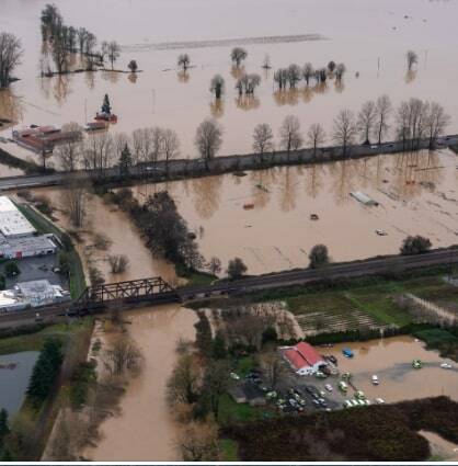
The City of Auburn announced that as of 4 p.m. Thursday, the Green River had crested at about 68 feet, and by Friday morning had receded to 67 feet.
“We saw promising developments this morning with stormwater and river flooding water having a chance to drain after the ground remained saturated on Thursday,” the city announced on its Facebook page.
Having declared a statewide emergency on Thursday, Governor Bob Ferguson sent an expedited request for an emergency declaration to the federal government, which President Trump signed.
The emergency declaration allows the state to seek federal funds for recovery. An expedited emergency declaration from the federal government allows access to life, safety and emergency protective measures and additional federal resources.
Ferguson has also activated the state National Guard.
“I want to encourage all Washingtonians to listen carefully to alerts from your county and emergency management departments. If you receive an evacuation order, please follow that order. It’s critical to your safety,” Ferguson said.
The city said it has not yet moved into a recovery phase but will remain in active response throughout the weekend, so it is asking for the public’s help while navigating road closures and flooded areas.
In the meantime, The U.S. Army Corps of Engineers said it expects to release more water from Howard Hanson Dam on Friday. Over the weekend, the Corps will manage water levels behind the dam, to push the river back up to moderate flood stage by Monday or Tuesday.
“Because the Green River will rise this weekend, we are urging residents to remain on alert and monitor water levels near their homes, especially those who live near the Green River or S 277th St.” the city said.
The White River has receded and controlled releases are expected at Mud Mountain Dam, with minor to moderate flooding in Auburn. On the south bank of the White River near A Street, the city has set up temporary HESCO barriers.
The White River Trail east of A Street Southeast and west of the Roegner Park parking lot is still closed. For one’s own safety and the safety of the crews at work in the in the area, don’t go beyond the signs.
The following local roads that had been closed on Thursday, were open as of Friday afternoon:
•Both lanes of Northbound Auburn Way North between 49th and S 277th St. Traffic will be detoured to Westbound 49th St NE to B St NW.
•104th Ave. SE from SE 320th St to Green River Road SE
•Riverview Drive NE between 22nd St NE and Pike St NE
•Oravetz Rd SE between Kennedy Ave. SE and Kersey Way SE
•Pike St NE from 8th to 12th St NE
•277th between Auburn Way North and 108th (in Kent)
•49th St NE between Auburn Way North and I St NE
•D St NE and I St NE are closed between 49th St NE and S 277th St
Green River Rd SE is closed at 100th Ave SE to the city limits
West Valley Highway is closed between 15th St NW and W Main St for landslides and trees over the roadway. This roadway will remain closed through the weekend because of continuing concerns of saturated grounds and slide risks
The city has set up shelters at:
Ray of Hope Shelter – 2806 Auburn Way N. Auburn, WA
Peace Lutheran Church – 18615 SE 272nd St, Kent, WA
The shelter opens at at 4 p.m. and will be operational for several days under the management of the Red Cross. For additional information,all 1-800-RED-CROSS.
Here is what you need to do (Level 1):
• Stay informed;
• Monitor local news, National Weather Service alerts, and official updates from the Auburn, which will be posted on auburnwa.gov/flood, in addition to official social media channels like Facebook and BlueSky;
• Protect your property;
• Move vehicles, equipment, and trailers to higher ground;
• Elevate important items and electronics off the floor, especially in basements or ground-level rooms;
• Clear gutters, downspouts, and nearby storm drains of leaves and debris.
• Gather supplies;
• Assemble a “to-go kit” with medications, important documents, clothing, chargers, flashlights, food, and water;
• Make a plan for pets (carriers, leashes, food, medications);
• Talk with your household and neighbors:
• Review how you will leave if water begins to rise and where you will go;
• Check in with neighbors who may need extra assistance.
Be on heightened alert, (Level 2) if:
• The river continues to rise toward your property;
• The City of Auburn, King County, or emergency officials issue additional warnings. You can sign up for alerts through King County if you haven’t already;
• You see water ponding in your yard, driveway, or around access roads;
During this phase:
• Keep vehicles fueled and parked facing out for a quick departure;
• Keep your to-go kit and any essential items by the door;
• Avoid walking or driving through standing water and do not go around “Road Closed” or “High Water” signs;
• Be prepared to leave quickly if conditions worsen or if you are asked to evacuate.
(Level 3) Leave if Conditions Become Unsafe
Leave the area immediately if:
• Water is approaching your home, garage, or access road;
• Emergency officials direct you to evacuate;
• You feel unsafe remaining in place for any reason.;
When in doubt, err on the side of safety. Remember:
Turn around, don’t drown. Just a few inches of moving water can sweep a vehicle off the road, and the depth and speed of floodwater can be deceptive;
Use higher, alternate routes if possible, and never drive around barricades or through flooded sections;
Flood Recovery Resources
As floodwaters recede, there can still be serious health and safety risks when returning home. Floodwater may carry contaminants, mold can begin growing within 24–48 hours, and damage can expose hazards like lead or asbestos.
King County Public Health has compiled clear, step-by-step guidance to help residents safely clean up and recover after a flood, including:
• Health and safety tips after flooding
• Mold cleanup and protective gear guidance
• What household items can be safely kept or should be discarded
• Lead and asbestos safety information
• Emotional and mental health resources after a disaster
• Multilingual resources for flood recovery
Visit King County’s Flood Recovery Resources.
Residents are encouraged to review these resources before beginning cleanup and to take precautions to protect themselves and their families during recovery.
Auburn residents and businesses should also fill out the following surveys to report flood damage.
• Residential Damage: KCOEM Residential Impact Survey
• Business Damage: KCOEM Business Impact Survey
Helpful Resources
For the latest information, please refer to:
• National Weather Service Seattle: Forecasts, river levels, and flood warnings
• King County Flood Services: Regional flood alerts and preparedness information
• U.S. Army Corps of Engineers — Seattle District: Reservoir and dam flow updates
• City of Auburn Emergency Management: Local preparedness tips and emergency notifications
• Auburn River Gages (White & Green Rivers): Real-time river level data
• Washington State Department of Transportation (WSDOT): Road closures and travel impacts
• Regional public information and notification service: ALERT King County & Pierce County ALERT
·
