
Auburn officials fear that another big storm could give residents along the Green River, especially in North Auburn, an unwelcome taste of what life was like before the construction of the Howard Hanson Dam.
An era when winter floods turned streets into streams, lapped at homes and transformed school yards into mini lakes on which boys floated makeshift rafts.
“A return to that,” said Sarah Miller, emergency preparedness manager for the City of Auburn.
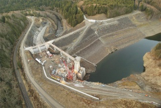
Driving the concern is the holding capacity of the pool behind the 47-year-old Howard Hanson Dam.
Army Corps of Engineers Spokesperson Casondra Brewster said that after the flooding in the second week of January, engineers assessing the dam found a depression or sinkhole, 6-to-10 feet in circumference on the right abutment of earthen material attached to the dam.
When engineers drop water or dye into the sinkhole, it comes out below.
“We’re not really sure what happened,” Brewster said, “and we are still investigating, but the problem appears to be related to the record pool level. What was really noticeable about the pool was not only was it kept high, but kept pretty high much longer than ever before.”
Engineers cannot fully evaluate the problem without lowering the pool level. At present the Corps has lowered the level to about 1/3 of its holding capacity. The upshot is that for the foreseeable future, the Corps will let the river run high, risking floods during high water events.
“They’ve lowered the dam to the lowest level that will still let water go through,” said Auburn Mayor Pete Lewis. “There will be no water being stored at the dam until they fix the dam between two and 10 years from now. It means flooding.”
A related problem is Mill Creek, which is connected to the Green.
“As soon as the Green overflows, water comes right down Mill Creek and completely fills up everything on the west side of 37th on West Valley under three to four feet of water. And we’re the small part. It’s four feet of water in Auburn, and if it tops, it is about 10 feet of water in Kent, Tukwila and Southcenter. This is an open river. There’s no holding back until they find the problem, and they don’t even know what the problem is yet.”
Brewster said nobody actually knows how long the Corps will require to complete its work.
“We’re still in the middle of the assessment to determine the extent of damage and what is causing it,” Brewster said. “It will take time. Our hope is to have full capacity before the next flood season. We are being conservative and cautious.”
Auburn areas considered to be at the highest risk include the area bordered on the west by West Valley Highway, on the south by 22nd Street Northeast, on the east by Green River Road and on the north by the city limits. Also included are all areas immediately adjacent to the Green River throughout the city limits.
City officials have been busy notifying people living in those areas. Throughout the weekend, volunteers from the the Emergency Management Division and the Police Department will go door-to-door to deliver public meeting notices for residents and business owners advising them of the increased flood risk.
The Corps has told the city there is no risk of dam failure and no immediate risk of flooding, but city officials say renters, homeowners and business owners should review their insurance policies for flood, water, landslide, and sinkhole coverage. Information on flood insurance can be obtained by contacting one’s insurance agent or by visiting www.floodsmart.gov.
People living inside the identified area may attend one of two currently scheduled public meetings, the first at 9:30 a.m. Saturday, Feb. 7 at Cascade Middle School and the second at 6:30 p.m. Tuesday, Feb. 10 also at Cascade. Businesses are invited to attend a meeting at 2 p.m. today at Emerald Downs Racetrack.
